The Caspian Sea Level Changes: Causes and Consequences
After the collapse of the Soviet Union in the early 1990s, the new independent Caspian littoral states faced with the necessity to adopt their own strategies towards the development of the coastal territories including energy and transport infrastructure improvement. However, since the Caspian Sea is the largest enclosed water body, which is as any lake characterized by large fluctuations in its water level, the Caspian Sea level (CSL) changes have a direct impact on the realization of the coastal industrial and transport projects. Therefore, as changes of the CSL fluctuation affect the coastal zones of all of the Caspian states, it becomes clear that the management of the CSL is a transboundary problem (Frolov, 2000).
As a result, the CSL instability with sharp falls and ups has become the subject of research in many regional scientific centers, especially Russian ones, as well as across the world. However, the causes of these climatic changes are not yet clearly understood. Over the last two centuries, the tide gauge stations located in Makhachkala (Russia), Fort Shevchenko (Kazakhstan), Baku (Azerbaijan), Turkmenbashi (Turkmenistan) and Anzali (Iran), from which the historical CSL observations are carried out[1], showed both upward and downward trends[2], which gave rise to additional concerns and speculations over the deepening ecological crisis in the region. For instance, the CSL decline in 1930-1977[3] led to shallowing of the coastal waters, especially in the northern part of the sea[4], which never reaches a depth of more than 25 m and is less than 5 m deep over two-thirds of its area (Planhol, 1990). The widening of the beachline was, perhaps, the only positive consequence of the fall in the water level. With a decrease in the CSL, the fields for raising fodder for the fish stocks in the northern Caspian were significantly reduced. Estuarial seashore shallow zone of the Volga River, which is very important for spawning and feeding of sturgeon juveniles, became rapidly overgrown with aquatic flora[5] causing deterioration of conditions for spawning and navigation. As a result, the Caspian fisheries production sharply reduced. Moreover, shipping was also suffering due to the fact that the depths in the navigation channels decreased, especially, in the Volga delta and along the coast of the northern Caspian.
Under these circumstances, the Central Executive Committee of the Soviet Union even started to consider the possibility to partially transfer the Siberian rivers flow to the Aral and Caspian basins.[6] In fact, in 1970, the USSR Government passed the Resolution No. 612 on perspectives of land reclamation and development for 1971-1985, flow regulation and redistribution. In 1976, the Siberian rivers flow transfer project was included in the Main Directions of the USSR Economy Development.[7] In April 1978, the USSR State Committee for Planning adopted the Resolution on basic provisions of the feasibility report on partial flow transfer of Siberian Rivers to Central Asia and Kazakhstan and the 26th Congress of the Communist Party of the Soviet Union approved the preparatory works on transfer of the Siberian rivers flow to the Volga basin, which might have stopped or slowed down the CSL decrease (Encyclopedia, n.d.). However, in 1978, the decrease in the water level suddenly changed to an increase, a large territory was submerged underwater, yet the previous levels were still never reached (Syrlybekkyzy, 2014). The rise in the CSL from 1978 to 1995 was not only unexpected but also resulted in economic collapse far worse than during downward trend. Indeed, both the economy and the population of the coastal regions have already adapted to a low level of the sea. As a result, a large number of enterprises, as well as small and middle-sized settlements found themselves in the flood zones. The CSL raise caused the flooding of the large areas of agricultural land. Countless roads and power transmission lines, industrial and fish-breeding enterprises were destroyed or damaged (Mikhailov, 2000). Consequently, the project on the partial transfer of the Siberian River flows to the Caspian basins was no longer relevant.[8] In fact, the only positive result of the CSL fluctuation in the mentioned period was improving conditions for upstream spawning migration to the Volga River delta, which became possible after the increase of shallow water depth in the Northern Caspian and reduction of areas occupied by water vegetation.
Since due to a sharp increase in the level of the Caspian Sea in 1978-1995, over 400,000 hectares of coastal areas were flooded, the high-ranking authorities of the coastal states put the creation of the flood hazard maps on the agenda. For instance, during this period only in Azerbaijan over 50 settlements, 250 industrial enterprises, 20 km of railways, 60 km of highways, and recreational facilities for 100,000 people experienced floods. By some estimates, it inflicted $2 billion in total economic damage for the country (Guseinova, 2007). As a result, the Marine Hydrometeorology Center of the Ministry of Ecology and Natural Resources prepared an atlas of coastal flooding maps aimed to identify areas prone to flooding. The other littoral states also developed similar atlas that helped to determine the scale of efforts to be undertaken in order to minimize losses. However, the last decrease in the level of the Caspian Sea which started in 1996 has reduced the need for updating the maps. However, obviously, the development of measures to protect the national economic assets and infrastructure, as well as coastal settlements from being damaged because of the CSL changes should be at the top of every Government’s list of priorities. Indeed, there is no doubt that the rapid sea level change of the Caspian Sea has a major impact on infrastructure and economic properties (Khoshravan, 2014). Therefore, crisis management and risk mitigation of fast fluctuations of the Caspian Sea are important and precisely forecasting can help the littoral states to prevent the next hazard (Khoshravan and Mammadov, 2017).
Throughout its history, the Caspian Sea has constantly experienced sea level oscillations. The latest trend of decrease of the water level of the Caspian Sea by 7 cm annually started in 1996 reaching a total of 1.5 m in 2015. Previously, the Caspian Sea hit the record low in 1978, after which, the continuous trend of the CSL decline shifted towards an increasing one up until 1995, increasing by 12 cm annually (Figure 1). Between the two time frames of 1979-1995 and 1996-2015, the average annual surface temperature increased by 1 °C and is expected to rise even further (Chen et al., 2017). However, it is still not clear if the CSL fluctuation results from large-scale rather than regional modifications in the atmospheric circulation patterns, nor if there is an impact from environmental (anthropogenic) transformations that have affected the Caspian Sea region (Cazenave et al., 1997).
Figure 1. Caspian Sea Level Change 1840-2015.
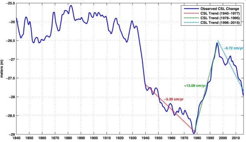
Source: Chen, J., Pekker, T., Wilson, C., Tapley, B., Kostianoy, A. Cretaux, J., & Safarov, E. (2017). Long-term Caspian Sea level change. Geophysical Research Letters, 44, 6993-7001.
Generally, endorheic water bodies such as the Caspian Sea are more sensitive to any changes. Water balance of the Caspian Sea is controlled by a number of different components such as inflow, the endorheic nature (no outflow) of the lake, water withdrawal for irrigation and land-use purposes, precipitation, and evaporation due natural and anthropogenic changes in climate, North Atlantic and El Niño oscillations, discharge to the Kara-Bogaz-Gol Bay, and tectonic movements. However, exact reasons behind the CSL changes remain unknown.
Most of the studies on the reasons for water level fluctuations of the Caspian Sea rely on the hydrologic hypothesis which is built on the effects of atmospheric circulation over the surface area of the lake and the surrounding areas. In hydrologic hypothesis, changes in the CSL explained by water budget rather than seismic activities and tectonic changes. Nevertheless, the tectonic hypothesis is also considered when studying the CSL. It is worth mentioning that tectonic movements cause a change in the volume of the basin and it can take from tens to thousands of years to affect the water balance. The two recent drastic changes of the water level of the lake in 1930-1940 (drop) and 1978-1995 (increase) were not linked to tectonic changes (Frolov, 1999). Also, the CSL fluctuation was explained by Heinrich Friedrich Emil Lenz in 1836 and Aleksandr Voyeykov in 1884 as a result of evaporation and precipitation (Syrlybekkyzy et al., 2014).
Many researchers suggest that the main reason behind the CSL fluctuations is the amount of inflow from the Volga River which accounts for 80% of water inflow into the Caspian Sea. The rest of inflow is obtained via Ural, Terek, Sulak, Samur and Kura Rivers. According to the Coordinating Committee on Hydrometeorology and Pollution Monitoring of the Caspian Sea, the main reason of the declining CSL is the lack of discharge from the Volga River (Syrlybekkyzy et al., 2014). Several studies have shown a correlation between the CSL increase in the period of 1978-1995 and heavy winter precipitation over the Volga River (Elguindi and Giorgi, 2006). Moreover, due to the shallowness of the northern part of the Caspian Sea, increasing area leads to higher rates of evaporation. In the second half of the 1980s, the evaporation rate reached 10 km3 annually (Syrlybekkyzy et al., 2014). Also, in the second half of 2010, abnormal drop in the CSL by 31-44 cm related to increased evaporation caused by hot and dry summer, and to the lessening of discharge from the inflowing Volga River (lower by 35 km3), was noticed (Syrlybekkyzy et al., 2014) (Table 1). The study by Elguindi and Giorgi (2006) shows that evaporation accounts for 40% of water budget of the sea majorly affecting the CSL fluctuations. Meanwhile, the study by Roshan et al. (2012) finds that precipitation and evaporation along with the amount of atmospheric carbon dioxide account for 87% of the CSL oscillations.
Table 1. Variation of the area of the Caspian Sea
| Sea level (m) | Northern Caspian (km2x1000) | Middle Caspian (km2x1000) | Southern Caspian (km2x1000) | Entire Sea (km2x1000) |
|---|---|---|---|---|
| -25.97 | 111.0 | 138.6 | 151.4 | 401.0 |
| -26.97 | 104.0 | 138.2 | 149.9 | 392.1 |
| -28.0 | 90.30 | 137.7 | 148.5 | 376.5 |
| -29.0 | 72.8 | 137.3 | 146.9 | 357.0 |
| -30.0 | 62.8 | 137.0 | 145.3 | 345.1 |
Source: Khoshravan, H., & Mammadov, R. (2017). The hydromorphology of the Caspian Sea. International Journal of Marine Science, Vol. 7(3), 19-30.
The recent study on the sea level change of the Caspian Sea by Chen et al. (2017) has concluded that the world’s largest lake has been shrinking during the last couple of decades due to the rising surface temperatures. The study concluded that half of the water level decrease was due to evaporation, while the rest of the decline was caused by the lack of precipitation and discharge from the inflowing rivers. Therefore, the drop of the water level is mainly caused by an increase of temperature in the region, and, in turn, the temperature increase is caused by climate change (Chen et al., 2017).
Often studies of not only past events but also modeling of the future changes of the Caspian Sea yield contradicting results. For instance, according to Chen et al. (2017), at the current pace, unless the amount of discharge and precipitation increases to balance out the increased evaporation, the situation is expected to get worse. Taking into account the shallowness of the water body, a water level decrease would eventually lead to the shrinking of the Caspian Sea. A continuous water level drop is especially dangerous for the northern part of the lake as it is only 5 meters deep. According to the study, at the current pace of evaporation-precipitation imbalance, the northern part of the Caspian Sea is at the risk of disappearing in about 75 years (Chen et al., 2017). Also, according to the climate change simulations by Elguindi and Giorgi (2006), despite the estimates based on the increase in precipitation over the Volga River, by the end of the 21st century, the CSL is to drop by 9 meters. Such major decrease in the CSL is linked to the absence of the period of stabilization or recovery. In contrast, statistical modeling of the CSL by Roshan et al. (2012) suggests that the water level of the Caspian Sea would increase by 85.73 cm in 2075 and by 162.71 cm by 2100. Moreover, most of the studies conclude that the CSL oscillations have an erratic pattern. However, water level reconstruction of the Kara-Bogaz-Gol Bay, which is an evaporitic bay located in the eastern part of the Caspian Sea, by Giralt et al. (2003) suggests that the water level fluctuations of the Caspian Sea follow a cyclical pattern based on the North Atlantic and El Niño oscillations affecting northern hemisphere.
Despite the different forecasts, the change of the water level of the Caspian Sea poses threat to the surrounding areas. If the water level declines further, there is a threat to the unique biodiversity of the water body. It is also worth mentioning that warming water temperatures have caused eutrophication (algal blooms) that leads to the decrease of oxygen levels and consequently, adversely affects marine life. Overall, drastic changes in the water level of the Caspian Sea would cause not only environmental consequences but also socio-economic ones such as damage to coastal enterprises, loss of livelihoods, migration and infrastructure degradation. The higher the rate of oscillation the worse these consequences would be. Therefore, it is important to conduct research aimed at discovering the main reasons affecting the CSL and constructing models that would provide reliable forecasts in order to prevent potential damage.
References:
Cazenave, A., Bonnefond, P., Dominh, K., & Schaeffer, P. (1997). Caspian Sea Level from Topex-Poseidon Altimetry: Level Now Falling. Geographical Research Letters, Vol. 24 (8), 881-884.
Chen, J., Pekker, T., Wilson, C., Tapley, B., Kostianoy, A. Cretaux, J., & Safarov, E. (2017). Long-term Caspian Sea level change. Geophysical Research Letters, Vol. 44, 6993-7001. doi: 10.1002/2017GL073958.
Elguindi, N., & Giorgi, F. (2006). Projected changes in the Caspian Sea level for the 21st century based on the latest AOGCM simulations. Geophysical Research Letters, Vol. 33 (8). doi: 10.1029/2006GL025943.
Encyclopedias. (n.d.). Encyclopedia of Aral Sea. Retrieved from http://www.encyclopedias.biz/encyclopedia-of-aral-sea/28456-o.html Accessed on: 12.09.2017
Frolov, A. (2000). New methods for managing the Caspian Sea level fluctuation. In N. M. William Ascher, The Caspian Sea: A Quest for Environmental Security (79-88). Springer Science & Business Media.
Giralt, S., Julia, R., Leroy, S., & Gasse, F. (2003). Cyclic water level oscillations for the KaraBogazGol-Caspian Sea system. Earth and Planetary Science Letters, Vol. 212, 225-239. doi:10.1016/S0012-821X(03)00259-0.
Guseinova, G. (2007). Kolebaniya urovnya Kaspiiskogo morya i ih posledstviya. Retrieved from http://www.1news.az/politics/20070619105240273.html Accessed on: 11.09.2017
Khoshravan, H., & Mammadov, R. (2017). The hydromorphology of the Caspian Sea. International Journal of Marine Science, Vol. 7 (3), 19-30.
Mikhailov, V. (2000). Zagadki Kaspiiskogo morya. Nauki o zemle. Retrieved from http://www.pereplet.ru/obrazovanie/stsoros/980.html Accessed on: 11.09.2017
Planhol, X. d. (1990). Caspian Sea i. Geography. Encyclopædia Iranica, Vol. 1, 48-50. Retrieved from http://www.iranicaonline.org/articles/caspian-sea-i Accessed on: 12.09.2017
Roshan, G., Moghbel, M., & Grab, S. (2012). Modeling Caspian Sea water level oscillations under different scenarios of increasing atmospheric carbon dioxide concentrations. Iranian Journal of Environmental Health Science and Engineering, 9:24.
Syrlybekkyzy, S., Kenzhetayev, G., Togasheva, A., & Tayzhanova, L. (2014). 17-year periods of rising and falling water levels in the Kazakhstan section of the Caspian Sea. European Researcher, Vol. 69 (2-2), 401-413.
[1] Systematic observations of the CSL were started in 1837 by scientists of the Academy of Sciences in St. Petersburg, who arrived at a corrected figure of – 25.51 m above mean sea level (AMSL) with the Black Sea as base line. Regular observations have been made at Baku since 1851.
[2] The average annual values the level of the Caspian Sea in the XX century is -27 AMSL m.
[3] In 1978, the CSL reached its lowest level, namely – 29 m, in modern times.
[4] It accounts for nearly a quarter of the total surface area of the lake but only 0.5% of the volume.
[5] Over 70 % of the area is covered with the growth of higher aquatic flora during vegetation period.
[6] The original idea was developed by Ya. Demchenko in 1871. Among the first developers of this project were such well-known engineers and scientists as the Monastyrievy brothers (1907-1923), B. Bukinich (1920-1930), N. Botvinkin (1924-1934), A. Miler-Schulga (1934-1950), I. Gerardy (1970), A. Voznesensky (1972), and G. Voropaev (1978).
[7] In the same year, the USSR State Committee for Science and Technology (SCST) approved a comprehensive scientific-technical program for 5 years (1976-1980), the head operator of which was appointed by the Institute of Water Problems (IWP) of the USSR Academy of Sciences.
[8] In 1986 the Central Executive Committee and the USSR Council of Ministers officially adopted Resolution on the termination of works on partial flow transfer of northern and Siberian Rivers.

Lidiya Parkhomchik
Senior Research fellow
Lydiya Parkhomchik (nee Timofeyenko) was born on February 9, 1984 in Zelenodolsk city, located at the territory of the Republic of Tatarstan (Russia). Since 1986 she became resident of the Republic of Kazakhstan. She graduated the high school in 2001 and at the same year she admitted to Abylai khan Kazakh University of International Relations and World Languages. She graduated from International Relations Department with specialization of analyst with knowledge of a foreign language in 2006 and after that started to work as a lecturer at the Chair of International Relations of KazUIR & WL.